
What’s happening today?
St Ronan’s Wells exists because of mineral water.
We saw in part 1 of this story “Where is the water?” that we have many questions about the site that we would like to find out more about.
In part 2 We looked at the chemistry of the mineral water and whether the site still has mineral waters.
This time I’ll start to piece together what infrastructure exists today and how it relates to the past.
Peter Stevenson Sept 2026
Please let us know if you have any thoughts, questions or information to add –
helpthewells@yahoo.com Facebook
The Well
Visitors wanting to see “The Well” are usually directed up to the top of the garden to see this –


Apart from Mary Kenny’s lovely “Doo well” painted ceiling and some faded information signs, sadly there is not much to recommend this as a visitor attraction.
Under the black metal grating is some stagnant water at the bottom of a tiled concrete cistern, along with all the detritus that has been dropped in, flaked off, or blown in there.
The cistern was emptied and cleaned in April this year (2026). This is what it looked like empty –


As regards tracing the mineral water heritage of the site, unfortunately this Well is just meant for sightseers.
Adjacent to The Well, on the paved area at the top of the garden, are some more historically interesting water tanks that have been hidden under wooden board covers since the Beechgrove Garden makeover in 2007 –


The Sulphur (?) Water Tank
Let’s see what is under the first one –


And when it was emptied –


Ross and Dorothy remember this as holding the sulphur water in the past. There was no sulphur smell, colour or deposits here in August 2026.
The Saline/Mineral Water Tank (?)
And under the second of the wooden covers –


Hmmm. This one is going to be a trickier proposition to investigate further! We haven’t attempted a clean out yet.
Let’s see what else we know…
A.N.Other Water Tank
Alongside the obvious large tanks there is more going on under the paving slabs –


Big Tanks
A final couple of pictures of manhole covers further down the garden that provide access to large but now empty concrete water tanks.


Lets see an overview of where all these water tanks (shaded blue) are located in the garden –

Now for some history compiled from the excellent historical maps provided by National Library of Scotland
The tanks have been overlaid on old OS Maps along with the modern path layout (coloured orange) for context –
1859 Map

1875 Map

1908 Map

Map Interpretation
Let’s have a closer look at these.
The oldest map is rather blurry but take note of the areas circled –

These become clearer on the next map which also has some useful symbols and labeling –

It’s useful to know that the symbol for a well or spring on these OS maps is a small open circle but it can also indicate a boundary post –

You can see a couple of these circles to the left of where “Mineral Springs” is written. Excitingly, this is where (all except one) of our blue tanks are now.
To the left of the word “Cistern” is a rectangle shape (circled in red) with another similar shape (also circled) under the letter “M”.
Intriguingly, one of these cisterns is on the other side of the wall from the modern garden.
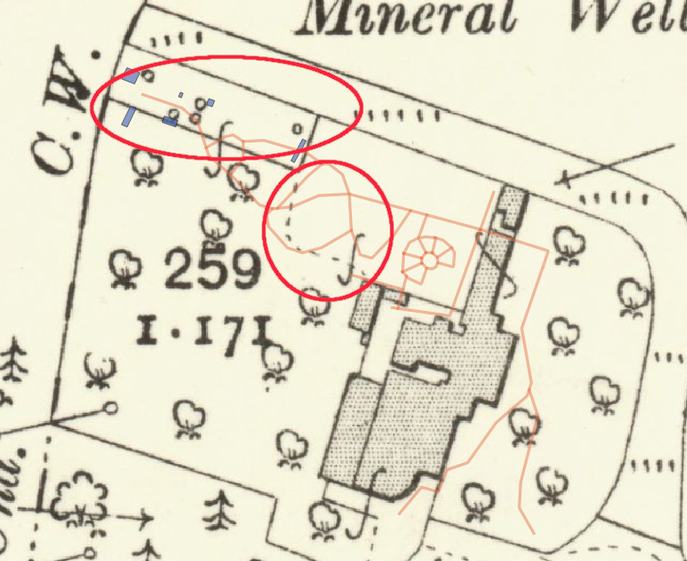
The 1908 map is less cluttered –

Now we have more small circle marks indicating springs, all in the same area as our present day blue tanks. There is now a rectangular boundary line drawn at the top of the garden (circled). The boundary encloses all of the springs and includes where there was a cistern on the older maps.
What is this boundary indicating?
A dashed line (circled) is drawn from the bottom corner of the boundary and it links up with one of the buildings. The buildings are indicated with a stippled pattern. The outline of the buildings is quite detailed on this map. The pavilion, house, bottling plant/museum etc. have the same shape as they have today, but the building that the dotted line arrives at, does not exist any longer. Looking back at the older maps, that building is on all of them. It pre-dates what we see today.
What was the mystery building?
So as always at the Wells site, more questions arise…
It would be great to be able to work out and reconstruct how the water tanks connect and how the water was collected and piped down to the pavilion and the bottling works. How much of that still works, or could be made to work?
If you think you know something that will help, or you want to comment or ask a question:-